China has been using satellite remote sensing technologies to search for the
 |
The Institute of Remote Sensing and Digital Earth under the Chinese Academy of Sciences used nearly a dozen satellites to search for traces of MH370, which has been missing since early Saturday after taking off from Kuala Lumpur for Beijing.
"In our searches for missing planes or boats, we could narrow down the search range gradually as we got more and more information. In this case, however, the search zone expanded continuously as more information came out, which was part of the reason for the lengthy search time," said Yan Dongmei, director of the science and technology department of the institute.
On March 9, scientists from the institute found oil slicks in the waters where the flight reportedly went missing. Yet after the search and rescue teams' analysis, the oil was not linked to MH370.
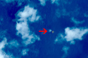
On Wednesday, the State Administration of Science, Technology and Industry for National Defense announced the discovery of three suspected floating objects on the water 6.7 degrees north latitude and 105.63 degrees east longitude, spreading across an area with a radius of 20 km.
"Satellite remote sensing can only provide some instruction for the rescuers to check," Yan said.
Being sent back by numerous satellites for five days, the information available was still limited because the satellites could only capture the image when it flew above the target region, Yan explained.
"Also, the noise of the sea water also influences satellite imaging. And the image can only detect objects floating on the water, with little knowledge about those that had sunk into the water," she said.
China has used satellite remote sensing technologies in international disaster reduction and rescues, such as in the Chinese icebreaker Xuelong's rescue of a Russian ship in December and January, and in helping Australia putting out forest fires in October.
chengyingqi@chinadaily.com.cn
 |
 |
|
No plane debris found at spot shown by China's satellite images |
Copyright 1995 - . All rights reserved. The content (including but not limited to text, photo, multimedia information, etc) published in this site belongs to China Daily Information Co (CDIC). Without written authorization from CDIC, such content shall not be republished or used in any form. Note: Browsers with 1024*768 or higher resolution are suggested for this site.
License for publishing multimedia online 0108263 Registration Number: 130349 ![]()