A walk to remember


Packed with elements of art, culture, history and nature, Shanghai's newly opened 45-kilometer waterfront trail along the Huangpu River is without doubt the city's latest landmark
Almost every major metropolis in the world has a river that runs through it.
There is the River Thames in London, the Seine River in Paris, the Hudson River in New York and the Neva in St. Petersburg.
Shanghai is no exception. Dividing the city into two halves, Puxi and Pudong, is the Huangpu River, a tributary of the Yangtze River that extends to the East China Sea. The water body is also affectionately called Shanghai's "Mother River" by residents. After all, the river has throughout history been a significant part in the city's rapid development.
From the late 19th to the early 20th century, the Huangpu River was where shipyards, factories, warehouses and banks sprouted, fueling Shanghai's transformation from a sleepy backwater into a vibrant trading hub.
At the turn of the new millennium, Shanghai began the restructuring of its core industries, marking the shift in focus to service and financial industries. This was also the time when the local government started to rethink the river's role in society.
The plan to transform the riverfront into a public green space was listed in the city's development plans for 1999-2020. The ambitious plan was again included in the city's three-year action plan for building public spaces along the river between 2015 and 2017. Some of the docks and warehouses from the past gradually disappeared from the landscape and were replaced by riverside parks and walking trails. Some factories along the river were renovated into art galleries.
In January, the redevelopment plan reached a milestone when the riverfronts on both sides of the Huangpu were connected in a scenic 45-km trail that is open to the public. From its northern end at the Yangpu Bridge, the trail meanders through five districts to its southern end at Xupu Bridge.
"The connection of the two trails is great for runners," said Xie Chuntian, 66, a running enthusiast who lives near the west bank of the river in Xuhui district.
"There used to be many dead ends on the trail and I had to exit and run along the inner-side road or turn around when the trail ended. Now, I can run along the river all the time, free from traffic and always in sight of the terrific views."
Bian Shuowei, an urban designer at the Shanghai Urban Planning and Design Research Institute, said that the most challenging task was connecting all these dead ends.
"There were around 100 areas that were occupied by different owners, including many State-owned companies and factories. In order to link the separate trails, we had to negotiate with many parties, request that some companies be relocated and build many skywalks and bridges," he said.
Qian Xin, a professor at the institute who was involved in compiling the guidelines for the trail, told Xinmin Evening News that the objective was to preserve the unique features of the riverfront while creating a sense of unity in the route. Authorities had also solicited the opinions of the public for the project.
The route features three lanes dedicated to walking, jogging and cycling respectively and are almost always flanked by flora and fauna. Trail users can also find public restrooms installed within 500 to 1,000 meters of one another.
Qian pointed out that the waterfront can be generally divided into three zones — a historical area that features the city's industrial legacy, a cultural space with museums and galleries, and a nature spot.
The 2.8-km section of the trail in Yangpu district is where a range of industrial buildings is located. There is a cotton mill as well as Shanghai's first water and power plants, all of which have a history of almost 100 years.
In Xuhui district, the 8.9-km trial links an array of museums and art galleries. The Yuz Museum was formerly an old hangar, the Long Museum used to be an old coal-loading dock, while the Star Museum was a railway station.
Chen Zihan, a landscape designer at the West Bund Group, the main developer of the riverside in Xuhui district, said that there would be 10 museums open to the public along this section of the trail by 2020. He added that the West Bund group has also signed a memorandum of understanding with France's Pompidou Center to hold an art exhibition at the West Bund Art Museum which is scheduled to open by the end of 2018.
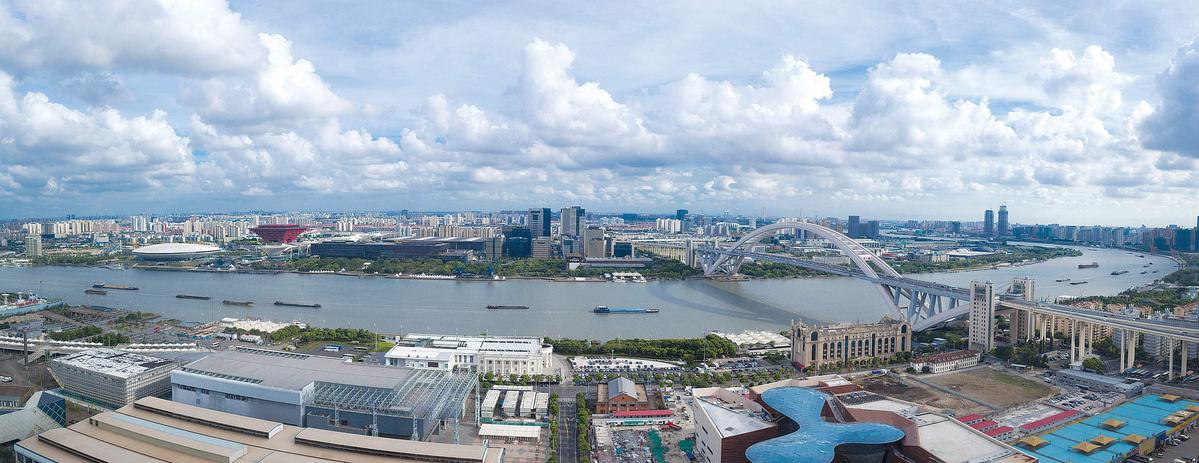
Over at the 2.5-km section of the trail in Hongkou district, people can take in the view of skyscrapers in the city's Lujiazui financial area. This is considered the main attraction of the trail.
To help the public better understand the trail, the Shanghai Surveying and Mapping Institute released an online map of the trail in December. On it, people can identify where attractions, restrooms and public transportation facilities are located.
xingyi@chinadaily.com.cn