About Haiti
Q&A about Haiti earthquake
(cctv.com)
Updated: 2010-01-14 15:44
 |
Large Medium Small |
|
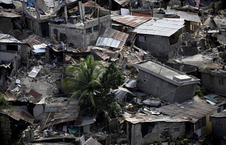 Destroyed buildings are seen after a major earthquake hit the capital Port-au-Prince January 13, 2010. [Agencies] |
The earthquake that devastated Haiti Tuesday was the strongest temblor to hit the island nation in more than 200 years. The magnitude 7.0 quake caused tremendous damage that officials have yet to fully characterize, and the death toll may run into the thousands.
What caused the Haiti earthquake, and why was it so devastating? Here are answers to these and other questions:
What caused the earthquake?
The shaking started on Tuesday, Jan. 12, at 4:53 p.m. EST (21:53 UTC) in the Haiti region, just 10 miles (15 km) southwest of Port-au-Prince.
The Haiti earthquake occurred at a fault that runs right through Haiti and is situated along the boundary between the Caribbean and North American plates, which are rocky slabs that cover the planet and fit together like a giant jigsaw puzzle. These two plates constantly creep past one another, about 0.8 inches (20 mm) a year, with the Caribbean plate moving eastward with respect to the North American slab.
"Twenty millimeters a year of slippage is very small, and that's not what people felt," said Carrieann Bedwell, geophysicist with the US Geological Survey (USGS) and the National Earthquake Information Center (NEIC).
Rather, they felt the release of energy from the Enriquillo-Plaintain Garden fault system. "The two sides of the fault line moved past each other in an east-west direction and that's what caused the energy release and the Haiti earthquakes," Bedwell said.
The high magnitude of this quake took scientists by surprise, as this system of faults hasn't triggered a major temblor in recent decades. The fault has, however, been linked to some historical big ones in 1860, 1770, 1761, 1751, 1684, 1673 and 1618, though none of these has been confirmed in the field as associated with this fault, according to the USGS.
What does a magnitude 7.0 mean?
Magnitude measures the energy released at the source of the earthquake. Since magnitudes are given on a logarithmic scale, a 7.0-magnitude earthquake would correspond to 10 times greater ground motion than a 6.0-magnitude temblor. The total amount of energy released by the earthquake, however, goes up by a factor of 32 for every unit increase in magnitude.
Geoscientists also look at an earthquake's intensity, which measures the strength of shaking produced by the earthquake at a certain location and is determined from the effects that shaking has on people, structures and the environment.