A high-tech push to stop wildfires
Updated: 2013-07-21 08:25
By Kenneth Chang(The New York Times)
|
|||||||
|
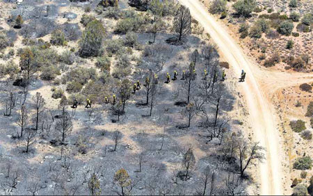
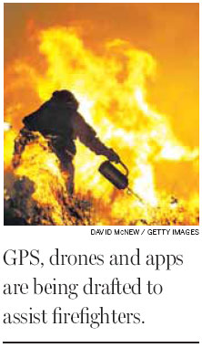
Technology is being tested to protect firefighters' lives. The Yarnell fire in Arizona killed 19; below, the Esperanza fire in 2006 in California killed five. Tom Tingle / Associated Press |
When the winds change, a forest inferno can make a sharp turn, and the fire crews battling it may need to depend on their eyes and instincts to tell them whether they are in danger.
Sometimes, as appears to be the case in the deaths of 19 elite firefighters in Arizona on June 30, it is already too late.
Of course, the best way to fight catastrophic fires is to keep them from growing to catastrophic scale. Scientists predict global warming will make wildfires more common. By 2050, experts predict, the annual extent of forests burned will rise by 50 percent in the United States.
So officials and experts are increasingly relying on technology to counteract the trickery of raging wildfires.
In computer simulations, the United States Forest Service sets tens of thousands of virtual fires - factoring in different weather patterns, topography, vegetation and historical weather patterns.
Weather satellites capture thunderstorms as they form, giving hints of the gusty winds that often accompany them. Remote-controlled unmanned aircraft, flying over a blaze for hours, can take infrared photographs that show its shifting edges.
Those images could be beamed to iPads and Android tablets carried by the firefighters.
"That information could all be available on mobile devices in real time so folks could reference that periodically as they're out in the field fighting the fire," said Tim Sexton, who manages the Forest Service's Wildland Fire Management Research, Development and Application program.
This summer, in a pilot program, the Forest Service is testing out Android tablets. Last year, the agency tested iPads and smartphones.
"They exceeded expectations," Laura L. Hill, an information technology strategic planner for the Forest Service, said of the iPads.
The Forest Service is using a mix of off-the-shelf software and custom apps tailored to the needs of firefighting. Ms. Hill said the agency also hoped to use cloud computing so data can be accessed from anywhere.
Burning forests often have no cell towers. "The real big stumbling block we've got right now that we've got to solve is how to get Internet connectivity to every fire every time," Mr. Sexton said.
Sometimes the Forest Service can set up a mobile cell tower or a microwave connection to the local telephone company that allows firefighters to use small antennas to communicate with one another.
Ms. Hill said another possibility was a computer network that allows firefighters to share information. If, for example, the leader of the crew had Internet connection via satellite, he would be able to download information and share it. Even if the Internet connection failed, the crew members could still share information with one another.
Such technology is already used by the United States military, the Homeland Security Department and the Federal Emergency Management Agency, she said.
Another challenge is gathering more complete knowledge about a fire. For larger fires, aircraft with infrared sensors fly over at night, producing a map. But updates during the day are based on incomplete and inexact visual reports.
An unmanned aircraft can remain aloft over the fire for hours at a time. The National Aeronautics and Space Administration collaborated with the fire service in 2007, providing a modified version of the Predator drone fitted with infrared sensors. The infrared sensors kept track of the movement of the fires that would otherwise have been obscured by smoke. "It was great information," Mr. Sexton said.
Mr. Sexton said that in the future, people in the command post might be able to see the precise position of each firefighter via a GPS receiver, as well as the current spread of the fire.
They would also have access to information like calculated safe zones to which firefighters could retreat, Mr. Sexton said. "We could remotely look at the locations of firefighters in relationship to where the fire is and the heat signature that it's producing, and perhaps anticipate movement of the fires before it reaches the crews."
The New York Times
(China Daily 07/21/2013 page11)