|
The Nujiang River is China's important river flowing from north to south. It has its source on the southern slope of the Tanggula Mountain Range in Tibet Autonomous Region, flowing across the Tibet Autonomous Region and Yunnan Province, with a total length of 2,816 kilometers and a drainage area of 324,000 square kilometers. The name of the river is changed into the Salween River after flowing into Burma from China, and it finally empties into the Andaman Sea of Indian Ocean at the Moulmein. The upper reaches of the river are known as the Naqu River in Tibetan. The river is called Anurimei by the Nu ethic minority, Anu is the name of the Nu people called by themselves, the Rimei means the river, so Anurimei means the river dwelled by the Nu people.
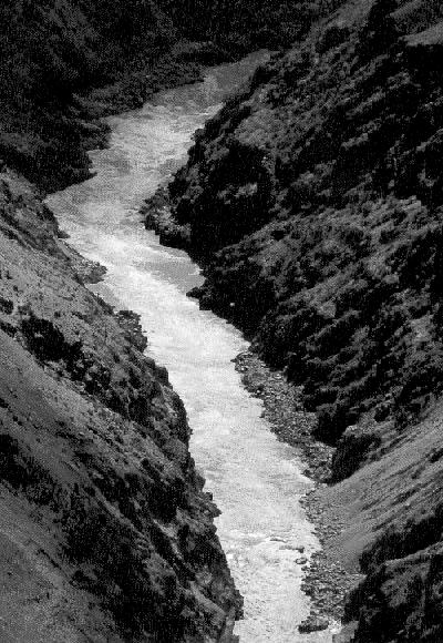
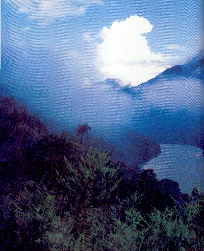
The Nujiang River surges forward between Gaoligong Mountain and Biluo Mountain. The altitudes of all the mountains beside the two banks are over 3,000 meters. As the drop height of the river is high, the river water is rapidly rushing and the wave is high, forming a very spectacular sight. There are many steep cliffs at both banks. Flowing toward the south with an annual water amount of 1.6 times that of the Yellow River, the river is impinging against the banks and thus forms the steepy Grand Gorge of the Orient with high mountains and deep valley. As affected by the southwestern monsoon climate of the Indian Ocean, the Grand Gorge of the Nujiang River forms a special climate that there are four seasons in a same mountain and the weathers are different within five kilometers. It is a common phenomenon that the trees are verdant and green in the river valley that is sweltering as in summer, the flowers are in full bloom and the grasses become yellow on the sidehill, and the mountaintop is the world of ice and snow as in winter. Biluo Mountain is situated at the east of the Nujiang River and Gaoligong Mountain is standing at its west, with snow peaks around the Grand Gorge.
The most strategic places of the Nujiang River are the Shuangnawadi Grand Canyon and the Qinatong Canyon. The Qinatong Canyon, with a length of 65 kilometers, is located at the Naqialuo segment from upstream Bingzhongluo to the Qinatong, and almost there is not any flatland. The steepy cliffs are standing beside the two banks, while the primitive forest is stretching to the horizon. The Yaguang River at the common boundary between the Jiangdong reaches and Tibet has many waterfalls, the highest waterfall is over 800 meters in height and more than 10 meters in width. The Nakaluo segment of the Qinatong has high mountains and deep valley and it is the most magnificent section of the Grand Gorge of the Nujiang River.
The hydroelectric resources of the Nujiang River are rich. In addition, there are also rich mineral resources in the Nujiang River reaches, such as copper, iron, lead, coal, crystal, graphite, isinglass, etc.
|