|
Natural heritage value:
Geological features
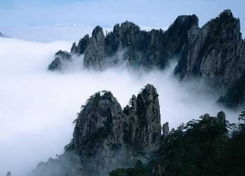
Experiencing orogenesis and crustal uplift in an extremely long period of time, as well as the influence of glaciers and natural weathering, Mount Huangshan formed its unique peak forest structure. Mount Huangshan is known for 'having 36 large-scale and 36 small-scale peaks' and its main peak, the Lotus Flower Peak, is 1,864 meters above sea level. The Lotus Flower Peak, the flat Bright Summit Peak and the precipitous Celestial Capital Peak are located in the heart of the Mount Huangshan scenic spot and surrounded by 77 peaks that are over 1,000 meters high. These overlapped peaks organically combined into a three-dimensional picture, looking rhythmic, magnificent and imposing.
The body of Mount Huangshan is mainly composed of granite from the period of the Yanshan Movement and has been developed into a vertical structure. It is strongly eroded and has crisscross cracks, and magnificent and beautiful granite caves and channels have been formed by long-term erosion from water. There are many ranges, canyons and dangerous places on the mountain, with a total of 30 ranges, 22 cliffs and two dangerous places. The rock mass on the front mountain has fewer joints and most are weathered into egg-shaped rocks, and the mountain body is very spectacular, while that of the back mountain has more joints and weathered into vertical rocks and the mountain body is very precipitous, forming unique geological features of 'majestic front mountain and beautiful back mountain'.
Remains of glaciers
Mount Huangshan has abundant glacial remains from the quaternary glacial epoch, which are mainly divided in the southeastern part of the front mountain. The typical glacial landforms include the U-shaped Kuzhu River and the Xiaoyao River which were formed by the glacial movement, the Eyebrow Peak and Carp's Backbone which have two V-shaped valleys and knife-shaped valleys formed by glacial scouring, the Tiandu Peak which is a horned peak formed by glacial scouring from three directions, the Baizhang Waterfall and Renzi Waterfall which are the hanging valleys merged by glacial valleys and its tributaries, glacial moraines formed by glacial movement and were distributed in the riverbeds between Xiaoyao River and some places including Tangkou, Wuniguan and Huangshidang, and the glacial mortars are the so-called the 'Danjing' and 'Yaojiu' where the legendary Emperor Xuanyuan made magic pills for immortality.
(cntv)
|