Satellite to improve weather forecasts
China will launch its latest independently developed weather satellite at the end of this year, which is said to be technically comparable to similar satellites being built in Europe and the United States.
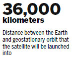
The FY 4 satellite, the country's second generation of weather satellites and also the newest member of its Fengyun series, will be launched into geostationary orbit 36,000 km above Earth, according to Qu Yan, deputy head of the Shanghai Academy of Spaceflight Technology under the China Aerospace Science and Technology Corp, which developed the satellite.
The satellite boasts world-leading technical capabilities in areas such as ground test sensitivity and spectral resolution, Qu said.
Nie Danrong, deputy director of the academy's department of application satellites, said that the satellite will lift positional accuracy to a new height of 1 km, four times more accurate than the previous generation, adding that it also has more detecting channels and improved ground resolution for its visible-light imager.
The Shanghai Academy of Spaceflight Technology is responsible for the research and development of all 14 satellites in the Fengyun series that have been launched since 1988.
"Each satellite has a different duty. For example, the FY 4 will be equipped with the country's first imaging sensor for the observation of lightning. Each generation of satellite in the series has higher precision performance in terms of target observation and data update frequency than the previous one," Nie said.
Researchers have said the satellites play an indispensable role in forecasting natural disasters such as typhoons, storms, floods and droughts.
Qu said: "Forecasting of typhoons has become increasingly more accurate, and the Fengyun satellites can be credited for this."
Since 2000, all typhoons formed and developed in the Western Pacific and South China Sea have been successfully detected and traced, he said.
China's meteorological satellites, together with those from the US and Europe, are used by the World Meteorological Organization, which means weather data collected by the satellites is made available to more than 3,000 weather forecast outlets in more than 90 countries and regions worldwide.
"As a member of the International Charter on Space and Major Disasters, China's weather satellites play an important role internationally. Data from our satellites directly informs weather forecasts across the globe," Nie said.
China plans to expand its network of weather satellites in the following decade to enable more precise detection of wind, rainfall and atmospheric composition, according to Nie.
"There will also be a satellite specializing in ecological and environmental monitoring, especially the long-term monitoring and forecasting of air pollution," he said.


- Is it a thing? 10 odd jobs where you can make good money
- Message on a bottle: Mineral water company launches drive to find missing children
- Sun Yat-sen champion of national integrity, unity: Xi
- Four killed, two injured after house collapses in C China
- Cross-Straits forum held to commemorate Sun Yat-sen