Remote system plays key role
After the magnitude-8 earthquake hit Wenchuan in Sichuan province in 2008, it took two days for rescuers to get remote sensory images of the affected sites.
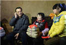
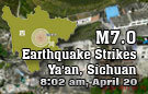
But on Saturday, when disaster struck Ya'an in the province, images of quake-hit areas were provided the same day.
 According to Guo Huadong, director of the Institute of Remote Sensing and Digital Earth, Chinese Academy of Sciences, a huge amount of airborne remote sensing data from Ya'an has now been distributed and shared with 12 ministries and the government of Sichuan.
The institute has also released images of pre-earthquake Lushan county, the epicenter, based on data collected by remote-sensing satellites before the earthquake struck.
"By comparing images of affected areas before and after the earthquake, rescuers can better evaluate the effects and find the best routes to affected areas," Guo said.
Satellite images have been downloaded around 7,000 times by users in China and other countries, including the US and Australia, he said.
One image of Baosheng township, one of the worst-hit areas, taken by a remote-sensing aircraft clearly shows the position and length of two road sections that were destroyed by landslides triggered by the earthquake.
The images, with a resolution of 40 centimeters, were obtained within hours of the earthquake, after an aircraft from the Institute of Remote Sensing and Digital Earth took off at 9:50 am from Mianyang airport in Sichuan, Guo said, a vast improvement over what happened in 2008, after disaster struck Wenchuan.
"Rain was falling in Wenchuan when that earthquake happened, which caused difficulties for remote-sensing aircraft taking pictures," Guo said.
"Besides, our aircraft were based in Beijing then, and it took some time before we even got permission to allow them to take off to head for Sichuan."
Military aircraft usually have priority in using airspace, Guo said. "Luckily this time, one of our aircraft was in Mianyang, which is closer to areas hit by Saturday's earthquake.
"Other related departments were also very supportive in allowing our aircraft to take off so quickly," he said.
Guo added the aircraft had been stationed in Mianyang since the Wenchuan quake to monitor reconstruction of the area and to guard against potential secondary disasters.
The quicker response to Saturday's earthquake provided timely information to allow government departments to make quick decisions on disaster relief, Guo said.
Liao Xiaohan, director of the National Remote Sensing Center of China under the Ministry of Science and Technology, agreed the country's responses were better this time.
"The country has improved its emergency response mechanism since 2008. This time, we reacted quickly and organized an information-sharing mechanism so all government departments could share remote-sensing data," he said.
Liao said there was a lack of information sharing in the past, and different remote-sensing institutes often obtained data from the same quake-hit areas, which was a waste of time and resources.
All remote-sensing data from Saturday's earthquake has now been transmitted to the National Remote Sensing Center for sharing between different departments, he said.
Bai Chunli, president of the Chinese Academy of Sciences, also hailed the role that remote sensing played in facilitating rescue and relief efforts after Saturday's earthquake.
"Remote sensing is becoming increasingly important in promoting economic and social development," he said in a speech ahead of the 35th international Symposium on Remote Sensing of Environment, being held in Beijing until Friday.
Cheng Yingqi contributed to this story.
Related readings:
Live report: 7.0-magnitude quake hits Sichuan
Premier urges full efforts to reduce deaths, injuries
Expert calls for rational volunteering, donations
Quake-hit region faces new threats
House damaged, life continues in Sichuan