|
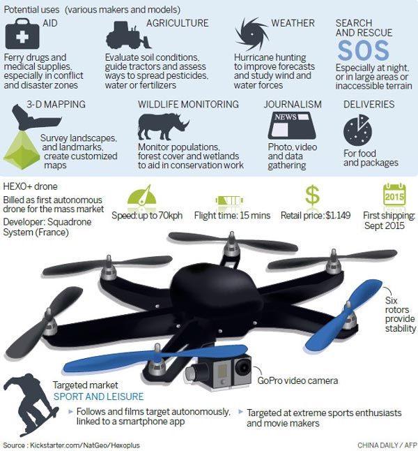 |
DJI and its rivals, including France's Parrot SA and 3D Robotics Inc of the United States, foresee demand for drones to shoot movies and news footage, survey farmland or oilfields, inspect power lines and oil pipelines and give firefighters a bird's-eye view of burning buildings.
Privately owned DJI, based in Shenzhen, declined to disclose sales or profit figures. But founder Frank Wang told the South China Morning Post in Hong Kong recently that revenue in 2013 was $131 million. The company said revenue grows by 300 to 500 percent a year.
For professional use, DJI launched its Spreading Wings series of bigger copters with up to eight rotors last year. They offer advanced steering and image-stabilizing systems and sell for up to $10,000.
Richardson, a former news photographer, said he got on DJI's waiting list for the latest Phantom model as soon as he read about it.
"I use it mostly to take pictures from vantage points that you couldn't get any other way," he said. Portsmouth's North Church has been around since the 1600s, but he gets photos of it that "have never been taken, ever".
In February 2012, DJI released its first full-fledged drone, the spindly Flame Wheel. Later that year, it added a camera to the first Phantom after seeing customers mount GoPro Inc's wearable video cameras on their drones.
Since then, research has spread to include cameras, software for imaging and control and stabilization systems. Expanding beyond drones, the company has used its know-how in stabilizing images to create the Ronin, a hand-held camera mount. Priced at $3,000, it is marketed as a lower-cost alternative to steady cam systems used by film and TV studios.
It opened its software-development process to outsiders to create additional tools. A Swiss software maker, Pix4D, has designed an application to transform images shot by DJI or other drones into three-dimensional maps. Huawei Technologies Co Ltd said its next smartphone model will have an app to control a DJI drone and receive live video.
Copyright 1995 - . All rights reserved. The content (including but not limited to text, photo, multimedia information, etc) published in this site belongs to China Daily Information Co (CDIC). Without written authorization from CDIC, such content shall not be republished or used in any form. Note: Browsers with 1024*768 or higher resolution are suggested for this site.
License for publishing multimedia online 0108263 Registration Number: 130349 ![]()