In November 1993, student Jennifer Koon was kidnapped and killed in New York state in the United States.
Before her death, the 18-year-old college sophomore and daughter of a New York state assemblyman managed to call 911, but police could not determine her position from the cell phone signal.
Three years later, the public safety network Location-based Services was established, allowing authorities to locate users through radio signals.
 |
|
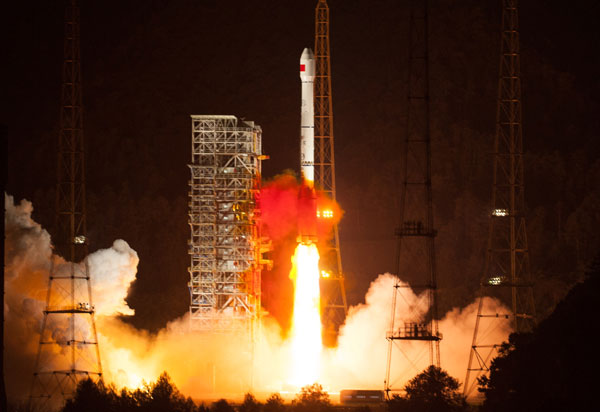
China successfully launches its 16th satellite for the Beidou system, a global navigation and positioning network, into space on Oct 25 from the Xichang Satellite Launch Center in Southwest China's Sichuan province. [Liu Chan / Xinhua] |
Now, in China, nearly two decades later, such services are not far away.
"LBS is nothing new. The reason we could not develop an LBS in China until now is that the Internet on mobiles only became popular in the past few years," said Shi Chuang, a professor at Wuhan University and director of the National Engineering Research Center for Satellite Positioning System.
"With LBS, we can integrate information on people ... and things, so that we can dig out business value," he said.
As a result, life can be made more convenient, such as through live monitoring of traffic congestion or monitoring dangerous and poisonous goods.
However, nothing can be accomplished without a highly accurate positioning system.
Paul Zandbergen, an associate professor with the University of New Mexico's geography department, carried out an accuracy survey on positioning systems on the 3G iPhone in 2009.
Results showed Wi-Fi locations using this phone had an average error of 74 meters for 58 observations, failing to meet the published accuracy specifications, while cellular positioning using this phone had a median error of 600 meters for 64 observations.
"Most pointing devices can pinpoint positions within 10 meters. But if we can improve the accuracy to less than a meter, it means we can accomplish many tasks that were not possible without a high-accuracy system," Shi said.
On Oct 9, China's National Remote Sensing Center said a new navigation system, Xihe, had been successfully tested to pinpoint positions within 0.1 meters outdoors and 3 meters indoors.
The system benefits business owners like Cao Hongjie, vice-president of Beijing UniStrong Science and Technology, a maker of navigation products.
"In the past, we designed different circuit boards for clients having different demands for the precision, but with Xihe, the precision difference can be controlled in operation centers, and we can use a device that applies to Xihe to provide services with different accuracy," Cao said.
For example, during China's last land survey, UniStrong designed several devices because accuracy requirements in eastern and western parts of the county vary by up to 50 times.
Cao said the device that sold best and which cost 15,000 yuan ($2,400) had an error factor of less than 5 cm. "But now I have developed a new version of the land survey device using the Xihe system, which is as good as the former and I'm planning to sell it for up to 8,000 yuan," he said.
"The new technology lowers the price, but gives me even more room for profit."
All eyes on you
You probably do not know that your car's GPS uses tracking information from at least three satellites watching you simultaneously to figure out your location.
Given the position of the three satellites and the speed that the signal travels from the satellites to your GPS receiver, your position is easily determined mathematically or thereabouts.
Some factors, like an atmospheric layer, can change the speed of the signal and influence the accuracy of the positioning.
Errors can be amended by empirical data, but this is expensive. Another approach to increase accuracy is to collect information from more satellites.
"This is like picking out one person from a large crowd," said Cao Jianlin, vice-minister of science and technology.
"If you only know the height of the person, you are probably not able to find him or her. But if you are given more information, like clothes or hair color, that will increase the accuracy."
As a result, a system that receives signals from different navigation satellite systems increases positioning accuracy without technology upgrades to improve the accuracy of the equipment itself.
Copyright 1995 - 2010 . All rights reserved. The content (including but not limited to text, photo, multimedia information, etc) published in this site belongs to China Daily Information Co (CDIC). Without written authorization from CDIC, such content shall not be republished or used in any form. Note: Browsers with 1024*768 or higher resolution are suggested for this site.
License for publishing multimedia online 0108263 Registration Number: 20100000002731 ![]()